A dormant volcano present on the Hawaiian island, Mauna Kea has a peak of 13,803 ft. (4,207.3 m) above sea level – making the mountain the highest point across Hawaii, and only the second-highest peak for any island. Mauna Kea is approximately a million years old, which means that its active shield stage has been over for several hundreds of thousands of years. Currently, the mountain is in a post-shield state, which makes its lava more viscous and gives it a steeper profile. Moreover, late volcanism has resulted in the production of cinder cones, giving the Mauna Kea a rougher appearance compared to its neighbor volcanoes. Other factors contributing to this excessively rough appearance are the rift zone decentralization, glaciation at the peak, and weathering caused by the trade winds. Mauna Kea last saw an eruption approximately 5,000 years ago, and, presently, it is considered to be dormant. The mountain has a peak that is around 125 ft (38 m) higher than that of its massive neighbor, the Mauna Loa.

The Hawaiian religion considers all the island peaks to be sacred. As per ancient law, only ali’i having high ranks can visit the peak. The ancient Hawaiians that resided on the Mauna Kean slopes relied on the mountain’s extensive forests for their food, while volcano-glacial basalts present on the mountain’s flanks fulfilled their tool requirements. With the advent of the Europeans in the latter half of the 18th century, sheep, cattle, and other game animals were introduced. Many of these animals became untamed and started impairing the ecological balance of the volcano. Recently, a lot of concern has been expressed about the native species’ vulnerability, leading to court cases and eventually compelling the Hawaii Department of Land and Resources to remove every feral species from the volcano.
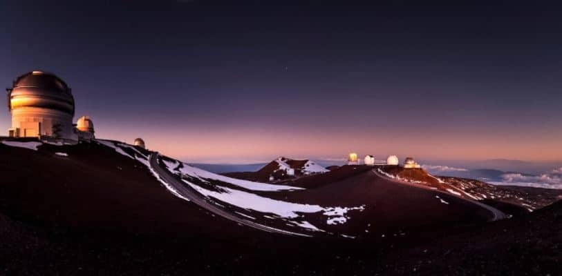
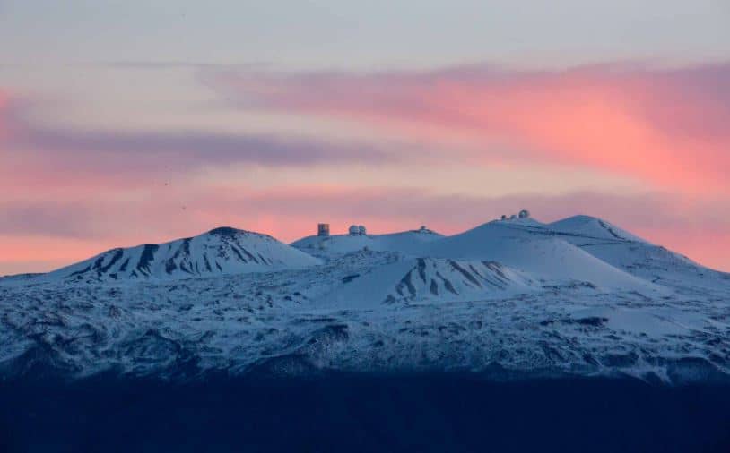
The high elevation, stable airflow, and overall dry environment make the Mauna Kea summit one of the best global choices for astronomical observers. Ever since an access road was created back in 1964, thirteen telescopes – sponsored by eleven distinct countries – have been installed at the summit. The observatories at the Mauna Kea are utilized for scientific research throughout the electromagnetic spectrum, and these observatories are considered to be the largest facility of this kind.
Recreation
The Hamakua Coast dominates the Mauna Kean coastline. The coast is a region of rugged terrain formed as a result of numerous landslides and slumps on the flank of the volcano. The region has several recreational parks, which include the Wailuku River State Park, Kalopa State Recreation Area, and Akaka Falls State Park.
The Hawaiian island has a quantity of registered hunters that exceeds 3,000 – hunting is a popular activity on the mountain, conducted for both sustenance and recreation. The quantity of introduced animals – such as sheep, pigs, goats, pheasants, quails, and turkeys – is controlled with the help of a public hunting program. The Mauna Kea Recreation Area serves as the base camp for the hunting sport. At the lower mountain levels, birdwatching is also a common pastime, with the Kipuka Pu’u Huluhulu being a popular site for this purpose. This kipuka was developed on the mountain’s flank as a result of the isolation of lava flows on the hill.
Thanks to its steep flanks and great height, the Mauna Kea offers a shorter hike and a better view compared to the adjacent mountain of Mauna Loa. However, the height, along with risks such as steep road grade, weather concerns, altitude sickness, and inaccessibility in general, make the summit trips hard and the volcanoes dangerous. Before the construction of roads in the middle of the 20th century, only the most daring of people made the journey to the upper slopes of the Mauna Kea – these included the hunters in search for game, and hikers looking to travel up the mountain. The stone cabins prepared by the Civilian Conservation Corps during the 1930s, acted as base camps for these travelers. When the first summit road for the Mauna Kea was constructed in 1964, it made the peak accessible to a lot more people.
Presently, several hiking trails – such as the Mauna Kea Trail – exist, and as of 2007, more than 100,000 tourists and more than 32,000 vehicles were visiting the Visitor Information Center (VIS) on a yearly basis. The VIS is situated adjacent to the International Astronomy Center of Onizuka. Mauna Kea’s access road has been paved up to the middle at 9,199 ft (2,804 m). According to a study, over 33% travelers and over 67% professional astronomers on the mountain had reported symptoms similar to those of acute altitude sickness. For this reason, any visitor who is traveling up the flanks of the volcano is advised to take at least a half-hour pause at the visitor center, to adjust to the high elevation. The use of a four-wheel vehicle is also stressed if you wish to drive all the way right up to the top. Brakes can often overheat on the journey downwards, and the Mauna Kea has no arrangements for fuel. Previously, a Star Gazing Program was held at the VIS, free of cost, during 6-10 PM every night. However, the program had to be canceled due to the COVID-19 pandemic.
Every year, around 5,000-6,000 people visit the Mauna Kea summit, and, for safety purposes and the protection of the integrity of this mountain, the authorities implemented a ranger program back in 2001.